


Gunung Leuser National Park
Posted: Jumat, 28 September 2012 by Afif 'Davit' Afriza in Label: ecology, geography, gunung, gunung berapi, gunung lauser, sumatra
0
Gunung Leuser National Park is a national park covering 7,927 km² in northern Sumatra, Indonesia, straddling the border of North Sumatra and Aceh provinces.[1] The national park, named after Mount Leuser (3,381 m), protects a wide range of ecosystems. An orangutan sanctuary of Bukit Lawang is located inside the park. Together with Bukit Barisan Selatan and Kerinci Seblat national parks it forms a World Heritage Site, Tropical Rainforest Heritage of Sumatra
Geography
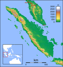
Gunung Leuser National Park is 150 km long, over 100 km wide and is mostly mountainous. 40% of the park, which is mainly in the north, is steep, and over 1,500 m. 12% of the Park only, in the lower southern half, is below 600 meters but for 25 km runs down the coast. 11 peaks are over 2,700 m and the highest point is Gunung Leuser, which 3 466 m high.Ecology

After put 28 camera-traps in July 2011, 6 months later the researchers found one male and six females and predicted the population is not more than 27 Sumatran rhinoceros which total population predicted is around 200 in Sumatra and Malaysia, a half population of 15 years ago.[6]
Ecological services
Water Supply As mentioned, the first signs of reduced water replenishment have already been seen in and around the Leuser Ecosystem. Groundwater reservoirs are rapidly being exhausted and several rivers fall completely dry during part of the year. This has severe consequences for the local community. Both households and industries need to anticipate water shortages and higher costs for water.[7]Fishery Coastal fisheries and aquaculture in and around Leuser are very important. They provide a large portion of the animal protein in local people’s diets and generate ample foreign exchange. Their annual value currently exceeds US $171 million. If the Leuser Ecosystem is degraded, the decline in fresh water may have a detrimental impact on the functioning of the fishery sector.[7]
Flood and Drought Prevention Flooding generally becomes more frequent and more destructive as a result of converting forests to other uses. Annual storm flows from a secondary forest are about threefold higher than from a similar-sized primary forest catchment area (Kramer et al., 1995). In Aceh, local farmers have reported an increasing frequency of drought and damaging floods due to degradation of the watercatchment area. In May 1998, over 5,000 ha of intensive rice growing areas were taken out of active production. This was the result of the failure of 29 irrigation schemes due to a water shortage. Furthermore, floods in December 2000 cost the lives of at least 190 people and left 660, 000 people homeless. This cost the Aceh province almost US $90 million in losses (Jakarta Post, 2000a). Logging companies are slowly recognising their role in increased flooding and have made large donations to support the victims (Jakarta Post, 2000b).[7]
Agriculture and Plantations Agriculture is a major source of income for the local communities around Leuser. Large rubber and oil palm plantations in northern Sumatra play a major role in the national economy. Almost all remaining lowland forest has been given out officially for oil palm plantations. Yield decline has been recorded, however, in several Leuser regencies. This decline can be ascribed mainly to a deterioration of nutrients in the soil, along with soil erosion, drought and floods, and an increase in weeds. Clearly, these causes of decline are linked to the deforestation of Leuser. For example, the logging of water-catchment areas in Leuser is found to be responsible for taking 94% of failed irrigation areas out of production (BZD, 2000a).[7]
Hydro-electricity Several regencies, such as Aceh Tenggara., have hydro-electricity plants that use water from Leuser. The plants operated in Aceh Tenggara are designed as small-scale economic activities. It appears that the operational conditions for the hydro-plants have worsened in recent years. Increased erosion of the waterways has forced the operators to remove excessive sediments from their turbines. This has led to frequent interruption of the power supply, higher operational costs and damage to the blades of the turbines. One plant closed down due to lack of water supply. Most of these disturbances are considered abnormal and may therefore be attributed to deforestation.[7]
Tourism Low-impact eco-tourism can be one of the most important sustainable, non-consumptive uses of Leuser, thereby giving local communities powerful incentives for conservation. Given the opportunities to view wildlife such as orang-utans, some experts view eco-tourism as a major potential source of revenue for communities living around Leuser (van Schaik, 1999).[7]
Biodiversity People living in areas with a high biodiversity value tend to be relatively poor. Hence, the highest economic values for biodiversity are likely to be found within institutions and people in wealthy countries. Funds can come from several sources, including bio-prospecting, the GEF and grants from international NGOs (with donations possibly being proportional to biodiversity value) (Wind and Legg, 2000).[7]

Carbon Sequestration Anthropogenic increases in the concentrations of greenhouse gases (such as CO2) in the atmosphere are widely believed to lead to climate change. Carbon sequestration by rainforest ecosystems therefore has an economic value, since the carbon fixed in the ecosystem reduces atmospheric concentrations.[7]

Fire Prevention To what extent does primary rainforest have a fire prevention function, and thus an additional value for preventing economic damage? There are various factors that make disturbed forest more prone to fires than primary forests. The likelihood that a forest will burn depends on the level of fire hazard and fire risk: (1) fire hazard is a measure of the amount, type, and dryness of potential fuel in the forest. Logged forest has relatively large amount of dry logging wastes lying around; (2) Fire risk is a measure of the probability that the fuel will ignite. In the presence of abandoned logging roads, which provide easy access to otherwise remote forests, the fire risk is greatly increased when settlers use fire for land clearance.[7]
Non-timber forest products NTFP can provide local communities with cash as long as exploitation does not surpass a threshold level